|
|
 | COASTAL ACTIONGeography Action Week - 1998 |
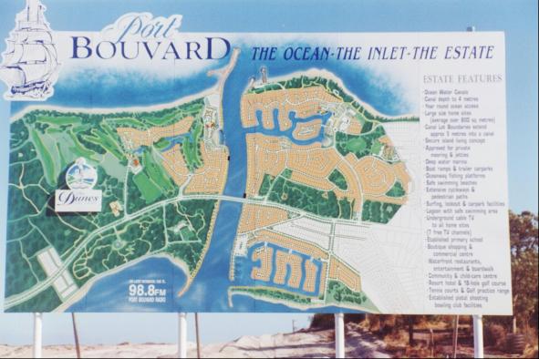 |
Figure 1 Peel-Harvey Inlet, Western Australia This is an advertising hoarding showing the canal estate developed along the newly cut Dawesville Channel. |
Peel-Harvey Inlet
This page has some supplementary information that could be used with the booklet distributed by the Australian Geography Teachers Association through its affiliates. The figures and limited information found here may make little sense without reference to the Coastal Action booklet.
The information provided here comes from very few sources. Students should seek opinions from a wide variety of sources and from the main people involved in the issue.
Students may find some useful sources of information in the Peel-Harvey links provided and are encouraged to search for more using suitable search and directory sites.
 |
The Peel region FACTS Distance: Mandurah is 74 km from Perth Area: the development zone is 5,700 square kilometres Population 1995: 61,782 |
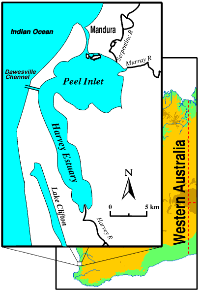
| Figure 2 Peel-Harvey Estuary map, Western Australia |
Further information
"The Peel region is the fastest-growing area in WA outside Perth and there is a need to ensure that future growth is properly managed in a regional context. There must also be an appropriate balance between environmental preservation and development.
"By the year 2026 the region's population is predicted to rise to about 150,000, so it is important that we decide now where the most appropriate areas for urban development are."
Mr Lewis said that protecting the environment was a priority in compiling the draft structure plan and a major issue addressed in the process was the proposed Peel Regional Park."A revised boundary has been identified which incorporates around 13,000 hectares of land and protects internationally significant features of the Peel Inlet-Harvey Estuary, including the Creery Wetlands boundary," he said.
"In addition, greenbelts have been incorporated in the plan to ensure the area does not become a continuous urban strip."
Source: Government Media Office
Ministry of Premier and Cabinet, Western Australia, 1996
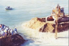 Figure 3a | 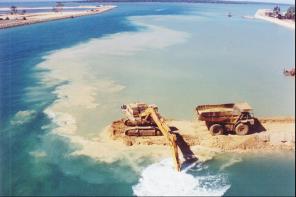 Figure 3b | 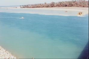 Figure 3c |
The environmental significance of the Peel-Harvey coastal wetlands
The Peel Inlet and Harvey Estuary (sea filled river mouth) and nearby lakes (See Figure 2) are so important that in 1990 they were listed as Wetlands of World Importance under the international Ramsar Convention. This area near Mandurah, in south western Western Australian, is a world renowned tourist spot because of its dolphins and the wonderful fishing and birds in the wetlands of the shallow lakes (less than 0.5 metres and up to 2 metres in Peel Inlet) and rivers just inland.
Almost a century ago local people warned that potentially damaging changes were occurring in the largest estuary on Australia's western coast. About 20 years ago 150,000 birds were recorded using these wetlands. These included 67 different species including ducks, swans and waders. It is a very important resting place for many of these as they migrate long distances around the world. These waters also have a large number of sh, Blue Manna Crabs and Greasy-back Prawns and is the biggest professional and recreational estuarine shing spot in WA. Lake Clifton is one of only two places in the world where a rare stromatolite-like calcium carbonate deposit is found.
By the early 1980s scientists were describing the Peel-Harvey as almost biologically barren.
The environmental issues in the Peel-Harvey coastal wetlands
Besides the tourism, shing and scientific importance of this place, as the region is only 80 kilometres (a bit over an hours drive) south of Perth it is a popular place to live and the rural land to the east has many dairy farms and piggeries. The concentration of peoples activities, especially the dairy and pig farming has caused a build up of nutrients in the wetlands. Several agricultural drains enter the eastern side of the water bodies so that animal waste, fertilizers and other chemicals and waste products drain into the water.
The water in this system was naturally flushed through the narrow estuary near Mandurah, but silt frequently clogged the ow and the nutrients (especially phosphates) increased causing a change in the balance of living things in the water. The main organisms to benefit were the algae and especially the beautiful but poisonous blue-green algae known as Nodularia. Very large blooms of algae have increased over the last 25 years. These cause several problems. As the massive amount of algae decays it uses most of the oxygen from the sediments. This starves many of the other plants and animals and upsets the normal food chain. Some algae smells foul as it decays. The Nodularia is a health hazard for human beings as they work or play on the water causing severe rashes or worse. Other animals also can be badly affected.
A solution?
The possible solutions to the problem of algal blooms are:
- those which stop the nutrients from getting into the water in the first place and
- those which help flush the nutrients from the system.
Because the farmers need to keep producing food and can not easily move it has been hard to reduce the materials that cause the problems. More careful handling of animal waste, fertilizers and chemicals to stop them getting into the water drainage system helps. Better management of the drains is also part of an answer. Similarly the many people who wish to live by the lake need to be very careful about what they put on the soil and allow to wash into the water system (e.g. fertilizer on lawns and oil spilt from cars and boats.)
Many people are worried that the rapid increase in housing by the river and lake shores will add to the pollution problem. (See Figure 1) This is a major concern because blocks being sold on canal systems give owners private boat moorings ve metres into the canal. The house lawns can sweep right down to the shore. residential wastes such as detergents from car washing, oil drips from driveways, lawn clippings and fertilizers all pose a threat.
Most effort has gone into improving the flushing of the wetlands. A channel, occasionally called the Dawesville Cut, 130 to 200 metres wide, 2,555 metres long and varying in depth from 4.5 to 6.5 metres was opened in January 1995. (See Figure 3) It extends some way into the ocean and has training walls to prevent sand clogging its mouth as is the problem for the river at Mandurah. The channel follows an old (thousands of years) river path to the sea. Since the channel has been opened the tidal level in the estuary now rises and falls about three or four times as much. It now takes about 50% less time for the estuary to flush.
Time will tell whether this solution is sufficient and appropriate for the future of the Peel-Harvey estuarine wetlands. You will need to find a good deal more information from a variety of sources before a final judgement can be made.
A couple of valuable sources of information about this issue are:
- Peel - Harvey : the Decline and Rescue of an Ecosystem, written by Mr Keith Bradby (1977). This book tells the human story of how European settlement and economic activity nearly destroyed one of WA's most important waterways and how people have begun to find a solution to the problem of the nutrient pollution and to restore the wetlands. This book is mentioned in Useful Box.
- Building a Better Peel Region is a publication of the Peel Development Commission. It outlines the Goals, Strategies, Activities and anticipated Outcomes of the Commission's plans for the region. Visit the Peel Development Commission Homepage.
|
|
|
|
|
|
| Return to top of page | Created: April 1998 |
Last uploaded on: |